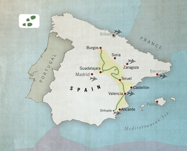
 Camino del Cid hiking route, Spain
The Way of El Cid for hikers covers a total length of 1497 km. It is divided into 7 thematic routes joined together over a length of between 50 and 308 km. All the routes are signposted and most have been approved as long distance hiking tracks (GR 160 – Way of El Cid).
These routes follow mainly historical or traditional routes and country roads across a geography of plains, mountains, valleys, hills and coastline. In some sections, the large country areas and low population density create a sensation of solitude and being far away from everything, a sensation hikers tend to value highly.
The routes are covered by all kinds of hikers and do not require any special technical skills beyond the basics needed for long distance hikes.
The information sheets for the routes have everything you need to know: guides, tracks, accommodation options, etc.
Also you can download the kmz track for Google Earth.
History, nature and rural areas in Spain
The Way of El Cid runs mainly through the countryside and rural areas. It crosses more than 70 protected areas and small villages; although the route also includes a number of large cities, such as Burgos, Valencia and Elche, more than half of the 387 villages included on the Way of El Cid have fewer than 200 inhabitants.
Signposting walking trails
The routes are signposted. Every year, we check the condition of the signs. However, given the length of the route, we recommend you travel with the information we offer on each route, which you can download free from our web site (route guides, maps and tracks, etc.).
Accommodation
We also recommend you to plan where you want to spend the night and book your accommodation in advance: you will be walking in areas with low population density. Some villages of the route are very small -which means that more than a half are below 200 inhabitants- and they have no accommodation or the number of beds available is limited. On each route, we offer information about hotels, guest houses, country houses, hostels, campsites and reception centres.
The routes
The hiking routes on the Way of El Cid offer a unique opportunity to cross Spain on foot through quiet, safe areas and to learn about the country's history and customs in a way you had never imagined:
- 2 days: Anillo de Gallocanta / Gallocanta Circular route (Zaragoza - Teruel). Difficulty: low-medium.
- 3 days: Ramal de Álvar Fáñez / The route of Álvar Fáñez (Guadalajara). Difficulty: low.
- 11 days: La Defensa del Sur / Defending de South route(Valencia - Alicante). Difficulty: low-medium.
- 12 days: La Conquista de Valencia / The Conquest of Valencia (Teruel - Castellón - Valencia). Difficulty: low-medium.
- 12 days: Tierras de frontera / The Border Lands (Soria - Guadalajara - Zaragoza). Difficulty: low-medium.
- 13 days: Las Tres Taifas / The Three Petty Kingdoms (Zaragoza - Guadalajara - Teruel). Difficulty: low-medium.
- 15 days: El Destierro / The Exile (Burgos - Soria - Guadalajara). Difficulty: low-medium.
Rev. ALC 18.05.18
Hiking Routes Travel Guides
-
The Exile hiking route guide 2020.pdf
16.64 MB -
The Borderlands hiking route guide 2020.pdf
16.23 MB -
Alvar Faez hiking route guide 2020.pdf
3.49 MB -
The Three Taifas hiking route guide 2020.pdf
16.44 MB -
Gallocanta hiking route guide 2020.pdf
1.82 MB -
The Conquest of Valencia hiking route guide 2020.pdf
15.13 MB -
Defending the South hiking route guide 2020.pdf
16.47 MB


